By Ron Pittaway
Please if you have any questions.

Carden Alvar |
Please if you have any questions.
PLEASE NOTE that Wylie Road north of the Sedge Wren Marsh and Alvar Road are not being maintained. Birders are cautioned to use these roads at their own risk.
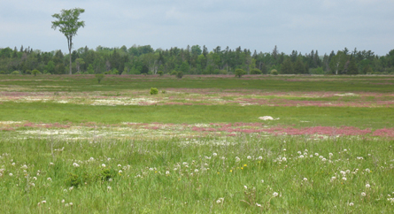
The Carden Alvar is designated an Important Bird Area (IBA) by Birdlife International. Carden is nationally significant as one of the last strongholds of the Eastern Loggerhead Shrike in Canada and it has high populations of grassland and scrubland birds such as Upland Sandpipers, American Kestrels, Common Nighthawks, Eastern Whip-poor-wills, Eastern Bluebirds, Brown Thrashers, Golden-winged Warblers, Bobolinks, Eastern Meadowlarks, Eastern Towhees, Clay-colored Sparrows, Vesper Sparrows and Grasshopper Sparrows.
The breeding birds are best in late May and June, but any time in May to mid-July is excellent. Weather is cool to warm in May, warm to hot in June, and hot in July. Poison Ivy is common along roadsides. Learn its three distinctive leaflets and avoid it. Insects are rarely a problem during daytime, but bring repellent just in case. Mosquitoes are active near wetlands just after sunset.
The Carden Alvar is a 1.5 hour drive (125 km or 75 mi) northeast of Toronto. See small inset map at top left of map. Carden is an easy day trip from the Hamilton to Oshawa corridor. From Toronto, take Highway 401 or Don Valley Parkway to Highway 404 north to Newmarket. Exit to Davis Drive and go right (east) to Highway 48. Turn left (north) on 48 and continue to where it meets Highway 12. Go left (north) on Highway 12 about 12.5 km and exit right (east) to Durham Road 48, which becomes Kawartha Road 48. Go 19 km to Kirkfield. At main intersection, turn left (north) on Kirkfield Road 6 and go 3 km to the Lift Lock where tour begins.

Eastern Bluebird
Photo: Brandon Holden
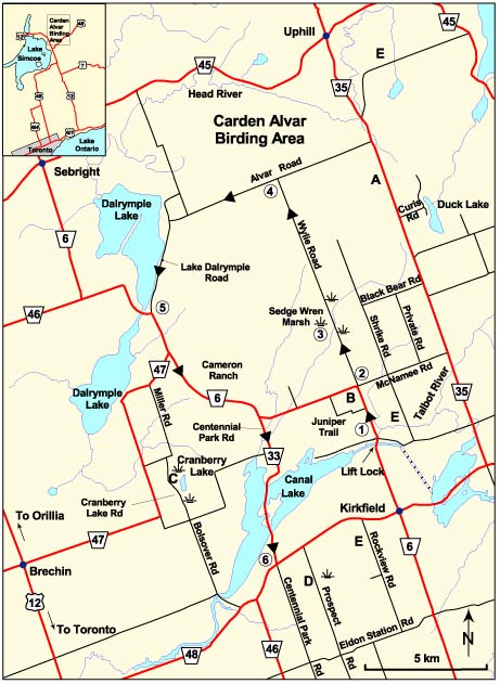
The 35 km (21 mile) route begins at the Kirkfield Lift Lock and ends at Kawartha Road 48 about 5.5 km west of Kirkfield. The 6 stops are enclosed in circles on the map and distances between stops are given in the route descriptions. At Stop 1 set odometer to zero. Distances between stops are cumulative. Relax and go slowly. Bring a lunch and get set to experience an abundance of grassland and scrubland birds as they were 75 years ago in southern Ontario before intensive agriculture. Scan the tops of shrubs, tufts of grass, boulders, dead trees and fences for singing birds. Use your telescope to get close views of grassland birds.
The Trent-Severn Waterway, operated by Parks Canada, connects Lake Ontario and Lake Huron. There is a pay parking lot ($2) on left just after underpass, but I suggest going first to Wylie Road and return later for a picnic lunch. Facilities include washrooms, picnic tables and nearby Joy-C's Place Restaurant. Birding at Lift Lock is excellent. Check swallows for Cliff and Northern Rough-winged. Stairs on east side of Lift Lock lead to a panoramic view. Scan for hawks and Osprey. Walk narrow trail going west 0.4 km along north edge of canal to where it meets Talbot River. Be careful along edge of canal. Return by going up the bank and birding alvar meadow and shrubbery back to Lift Lock parking lot. You cannot get lost here, being surrounded by the river, canal and road. This is public land owned by the Government of Canada.
Wylie Road is the best early summer birding road in southern Ontario. From the Lift Lock, drive 2.5 km north, turn right (east) on McNamee Road where the highway turns sharply to the left. You will see the sign for the Important Bird Area on your left. The Nature Conservancy of Canada and OFO use the name Carden Alvar instead of “Plain” because alvar is a precise term that better describes Carden’s global significance. Turn left (north) almost immediately on Wylie Road. This narrow road ends 9.4 km to the north at a “T“ intersection at Stop 4. Watch and listen for American Kestrel, Northern Harrier, Wilson’s Snipe, Upland Sandpiper, Eastern Kingbird, Cedar Waxwing, Eastern Bluebird, Tree Swallow, House Wren, Gray Catbird, Brown Thrasher, Warbling Vireo, Savannah Sparrow, Vesper Sparrow, Grasshopper Sparrow, Bobolink, Baltimore Oriole, Eastern Meadowlark and many other species. A singing Henslow’s Sparrow was seen in the meadow west of the road at 0.2 km in late July and early August 2006. Watch for Loggerhead Shrike about 1.8 km north of the intersection on both sides of the road near bluebird boxes 9 and 10. There is a parking area and viewing shed if it is raining.
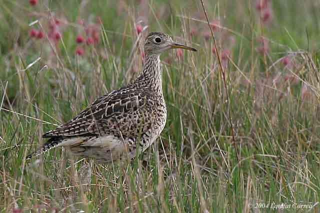
Upland Sandpiper
One of a pair
Photo: Latafat Correa
There is a small parking area on the left just before the marsh. The marsh is designated a Provincially Significant Wetland. It is a reliable spot to find Sedge Wren. At dawn and dusk, you should get Wilson's Snipe, American Bittern, Common Nighthawk (overhead) and Eastern Whip-poor-will (heard). You may hear Virginia Rail and Sora. Yellow Rail is heard here from late April to late May with peak singing in mid-May. Walk the road on both sides of bridge. Listen and watch for Alder Flycatcher, Common Yellowthroat and Swamp Sparrow. The trees and shrubs on both sides of the marsh along the road are excellent for songbirds.
It is 6.6 km from Sedge Wren Marsh to Alvar Road at the Carden “T”. This section goes through dry and wet meadows and scrub rich in songbirds. Drive slowly and stop often. Golden-winged Warbler, Indigo Bunting, Eastern Towhee and Field Sparrow are in scrubby areas with scattered trees. Rarities such as Prairie Warbler and Lark Sparrow have been sighted along this section of the road. Listen for Clay-colored Sparrow about 0.5 km before the “T”. Watch for patches of Prairie Smoke (Geum triflorum), a characteristic alvar wildflower. At night, drive and watch for the bright eyeshine of Common Nighthawk and Eastern Whip-poor-will sitting on the road. Listen for Coyotes.
Go left (west) on Alvar Road. It is 4.7 km to the Lake Dalrymple Road. This section goes through coniferous woodland with scattered alvar openings. Singing Hermit Thrush, Blackburnian Warbler, Magnolia Warbler, Chestnut‐sided Warbler, Nashville Warbler, Yellow‐rumped Warbler, White‐throated Sparrow, Purple Finch and sometimes Evening Grosbeak lend a northern flavour. Listen for croaking Common Ravens. Look for Scarlet Tanager in mature mixed woods singing from a high perch (often a dead branch), but hard to spot. Turn left onto Lake Dalrymple Road and you soon enter a cottage area on Lake Dalrymple. A resort store has soft drinks coffee, snacks, washroom and gasoline. South of the store 1.3 km, opposite a rock cut on the left, is a good view of the lake. Check for Common Loon and Black Tern. Continue a short distance to the Prairie Smoke Alvar Nature Reserve parking lot and sign on the left. Explore a variety of alvar habitats on foot along a 2 km trail leading straight back from the sign.
Turn left onto Kirkfield Road 6. Go 5 km to the vast open alvar dotted with hawthorns on your left. This is the 2869 acre Cameron Ranch acquired in 2003 by the Nature Conservancy of Canada that will become part of a new Carden Alvar Provincial Park. Signs commemorate the donors and stewardship partners. A 1.5 km dead end trail leads from the parking lot. Scan the ranch for Loggerhead Shrike and Horned Lark. Continue 2 km and turn right on Road 33 (Centennial Parkway), which leads to the causeway across Canal Lake. There are several Osprey nests on platforms. Watch for Common Loon and Common Tern. Continue to Highway 48 where the tour ends. Turn right for Toronto or left for Kirkfield.
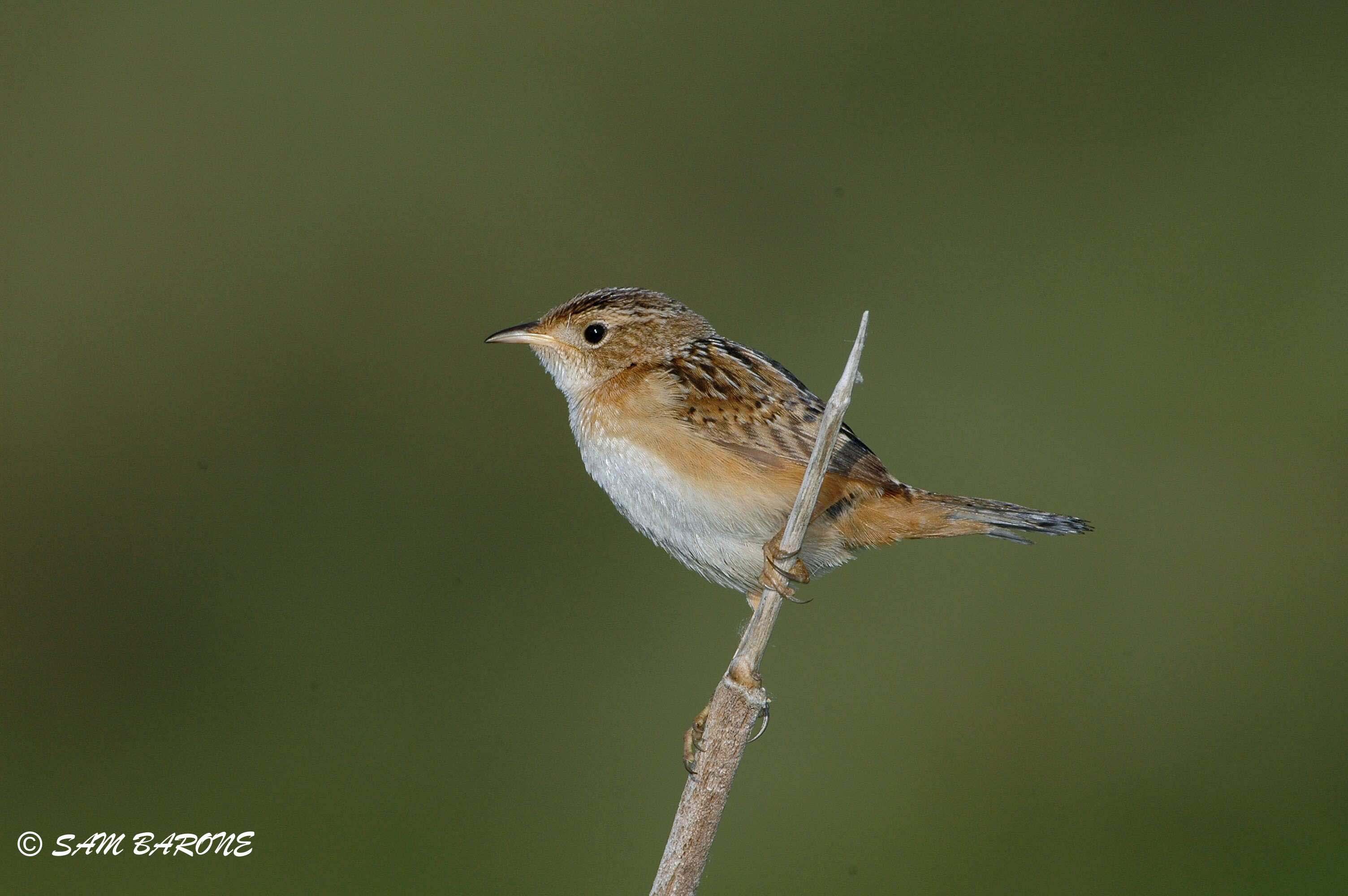
Sedge Wren
Photo: Sam Barone
Also called Victoria Road. Instead of going left (west) on Alvar Road at Stop 4, go right (east) to Kawartha Road 35. Be careful turning right (south) at this blind intersection. Kawartha Road 35 is paved, but traffic is light. Bird your way to Kawartha Road 48. Watch for Loggerhead Shrike in the hawthorn pasture north and east of the junction of Curis Road (or Curl's Road). Turn right on Kawartha Lake Road 48 and go 4.5 km to Kirkfield. Or go east from Kirkfield to Kawartha Road 35 and go north (left). Do not confuse Kawartha Road 35 with provincial Highway 35, which is 14 km farther east at Coboconk.
Accessible from Kirkfield Road 6 on left 1 km north of the Lift Lock or go another 2 km to the north entrance. Most grassland birds, including Loggerhead Shrike, are possible here. Allow 2 hours to walk 4 km return trip. Do not drive Juniper Trail without a 4‐wheel drive or high clearance vehicle.
This road goes south from Kawartha Road 48 about 4.0 km west of Kirkfield. Large marsh 2.5 km south of 48 has American Bittern, Least Bittern (rare), Sora, Virginia Rail and Marsh Wren. The next 8.5 km is rich in birds from marsh to Glenarm Road 8 through scrub, meadows, swamps and woodlots.
See map for letter E to explore other roads.
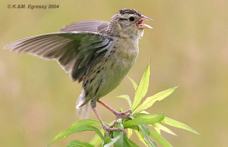
Bobolink
Fledgling
Photo: Karl and Marienna Egressy
Alvars are globally rare habitats supporting many Species At Risk. Alvars are naturally open areas of flat limestone or marble bedrock either at the surface (classic alvar pavement) or covered with thin soils and sparse vegetation of lichens, mosses, herbs and shrubs. Trees are usually absent, scattered or in clumps, but some alvars are treed. Plant growth is restricted by shallow soils and extremes of spring wetness and summer drought. Recent studies indicate the ecological role of periodic fires in rejuvenating alvar habitats. Much of the Carden Alvar is ranchland. Cattle grazing maintains the short grass preferred by Loggerhead Shrikes and many grassland birds. However, heavy grazing damages sensitive plants and alvar habitats. There are four active limestone quarries in Carden and others are expected because of increasing demands for crushed stone in the Greater Toronto Area. For more information see The Alvars of Ontario by V.R. Brownell and J.L. Riley (2000) published by the Federation of Ontario Naturalists, 269 pages.
Most of Carden is private property. The back roads are narrow, but traffic is usually light. Be careful not to block roads or laneways. There are some good spots to pull off, but check them on foot first. In spring and after heavy rains, some roads develop mud holes and washouts. Drive slowly, find a safe place to park, then bird from the roadside.
Be friendly to ranchers and others using the back roads. Birds are easily seen from roadsides without disturbing them. Keep the best interest of birds and their habitats in mind. Endangered species and their habitats, such as the Loggerhead Shrike and Henslow's Sparrow, are protected by Ontario's Endangered Species Act. Report anyone disturbing endangered species to the Ministry of Natural Resources at 1-888-TIPS-MNR (1-888-847-7667).
Cameron Ranch.
Photo: Valerie Jacobs
The “Eastern” Loggerhead Shrike (subspecies migrans) is endangered in Canada. Please view shrikes from a distance with binoculars or telescope. The following information is from Hazel Wheeler, Species Recovery Biologist at Wildlife Preservation Canada. Ontario is on the brink of losing its breeding population of Loggerhead Shrikes. The 2015 population was the lowest since monitoring began in 1991. The 2015 population consisted of only 11 confirmed nesting pairs, plus 1 probable breeding pair. This included 7 pairs on the Carden Alvar and 5 pairs in Napanee. In addition, there were 13 unmated shrikes: 9 in Carden, 3 in Napanee, 1 in Grey-Bruce (Wildlife Preservation Canada). The causes of the decline, which began over 50 years ago, are unknown. It is likely linked to increasingly intensive agriculture practices. Road kills, particularly during migration and on the wintering grounds, may be an important factor. Good breeding success occurs most years in Carden suggesting that pesticides are not affecting reproduction. Wildlife Preservation Canada is releasing captive bred Loggerhead Shrikes in Ontario to augment the population and increase numbers. Released shrikes wear a variety of colour bands. Look for shrikes in actively grazed pastures with short grass and scattered hawthorns. Ungrazed areas quickly become unsuitable breeding habitat because they overgrow with tall grasses, shrubs and trees. The song of the Loggerhead Shrike is poorly developed and it is rarely heard singing. Its song is a short series of disjointed, somewhat musical notes with accent on second syllable...ga‐Lupe...ga‐Lupe...ga‐Lupe. Adults have two distinctive call notes. The common alarm call is a raspy starling‐like meeg often repeated. They also give a higher pitched rasping freep. Young out of nest being fed by adults give loud screeching meeeeg begging calls similar to the adult’s call, but lower pitched and more drawn out. Juvenile Loggerheads in summer at close range are greyer overall with fine barring on the under parts (except the throat) with a more contrasting whitish throat and somewhat duller black mask. At a distance, adults and juveniles appear very similar, but adults usually show a conspicuous white wedge of feathers (sometimes hidden) between the black wings and grey back. This adult mark is formed by the white tips of the outer scapulars (grey in juveniles) and can be used to separate perched juveniles and adults in summer at long distances. The Northern Shrike occurs in Carden from late September to late April, but breeds in far northern Ontario.
For more information about identifying Loggerhead and Northern Shrikes click here.
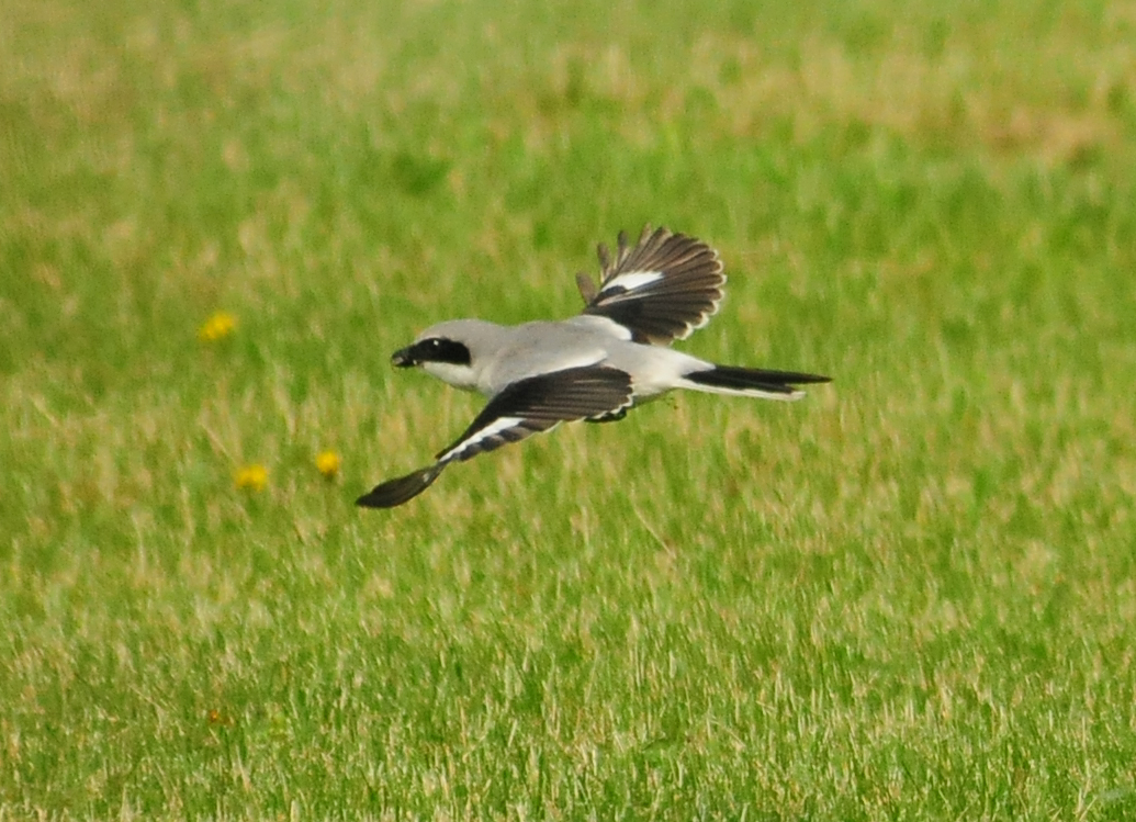
Loggerhead Shrike
Photo: Kurt Hennige
Please support local businesses. Birders contribute to the economy by buying gas, eating at restaurants and using accommodations. Proudly wear your binoculars. Tell people about grassland birds and importance of the Carden Alvar. The Lake Dalrymple Resort, 1‐705‐833‐2400 or their website, has housekeeping cottages from May to October, a convenience store with coffee, snacks, picnic tables, washroom and gas pumps. There are motels in Orillia and Lindsay. There is camping at Balsam Lake Provincial Park, 12 km east of Kirkfield. Call toll free 1‐888‐668‐7275 to reserve a campsite. There are restaurants at the Lift Lock and in Kirkfield and at the ESSO gas station 3 km east of Kirkfield. For more information visit City of Kawartha Lakes office in Kirkfield at 7 Monroe Street on the left one block southeast of the main intersection. It is open Monday to Friday 8:30 a.m. to 4:30 p.m. or you can call toll free 1‐888‐822‐2225.
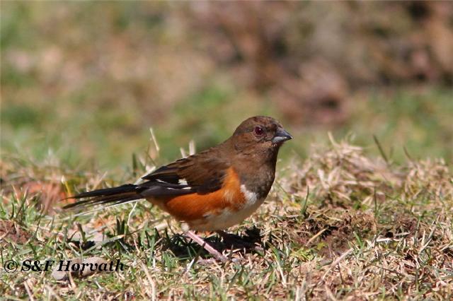
Eastern Towhee
Female
Photo: Sandra and Frank Horvath
I thank Jean Iron for comments and photos. Andrew Jano made the map. Mike Turner of the Ministry of Natural Resources, Minden Area Office, supplied background information on the Carden Alvar. I also thank Ron Tozer for proofing the guide, and Valerie Jacobs and Doug Woods for setting it up on the OFO website.